
Water on the Web – New Portal Goes Live
The website ‘Everything Flows – A German Water Balance’
The website ‘Everything Flows – A German Water Balance’
A new, interactive internet portal that shows the current situation regarding water in Germany was launched this week at www.bmbf.wasserfluesse.de. The Institute for Ecological Economy Research (IÖW) unveiled the website at the IFAT, the world’s leading trade fair for environmental technologies in Munich, which runs from 5th to 9th May 2014. The website can be used to look up information on topics including how precipitation and evaporation are distributed across the different regions in Germany, how power stations, industry and households use water, and what the possible future scenarios are for water availability in times of climate change. The portal is suitable for anyone who wants to broaden their knowledge of water-related issues, from schools to further education institutions to specialists working in the water sector or related fields.
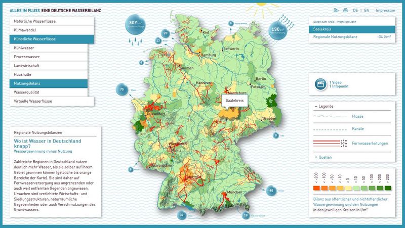
Water balances for over 300 administrative districts in Germany
The portal has been publicly available since Monday at the stand belonging to the Federal Ministry of Education and Research (BMBF) at the IFAT in Munich. Visitors can use a touchscreen table to go on a voyage of discovery across Germany and learn about the water balance in 300 administrative districts and cities with district status. Animated films provide visitors with a better understanding of water flows and make hard-to-grasp issues such as regional water shortages more tangible. The poster ‘Everything Flows – A German Water Balance’ shows a summary of the results. It can be ordered from the German Association for Water, Wastewater and Waste (DWA) or downloaded free of charge.
Germany: waist-deep in water
If the total annual precipitation that falls across Germany – from the North Sea to the Alps – did not run off or evaporate, the country would be 86 centimetres under water. That would be roughly equivalent to a waist-deep layer of water across Germany. The website presents ideas such as this one in a series of animated films, which make it easy to understand how much water is available in which parts of Germany, how much of it is used where, and what problems this can lead to at a regional level.
The interactive information maps and animated films were developed as part of the research project ‘Water Flows in Germany’, which is led by the IÖW and sponsored by the German Federal Ministry of Education and Research (BMBF) under the funding priority ‘Sustainable Water Management’ (NaWaM). The IÖW’s partners for this project include the German Federal Institute of Hydrology (BfG) and the German Association for Water, Wastewater and Waste (DWA).
Regional water shortages made visible
IÖW water expert Jesko Hirschfeld and his team began compiling and computing the data in 2011. “You can use the portal to see how we use water,” says Hirschfeld. “In many regions we have plenty of water, whereas in other regions we don’t have enough – and climate change could make it worse. The various interactive maps let you see straight away which regions are most affected.” Richard Harnisch, Head of Public Relations and Communications at the IÖW, highlights the fact that the water-related information is presented in a playful way: “With this interactive portal, which is the first of its kind, we are exploring new ways of providing information, with the aim of getting young people interested science.”
++++++++++++++++